The Tunnel
The "British fund for the discovery of Antiquities of Palestine" was famous through a British expedition during the period between 1867 and 1870 to carry out excavations at about twenty sites in Palestine, in order to search for the remains of the alleged temple, especially in Jerusalem and next to the Al-Aqsa Mosque.
In an attempt to find evidence or remnants of evidence on the Promised Land and the first and second structures, the most important of these excavations were concentrated around the Al-Aqsa Mosque from the western side, and the nearby southern neighborhood or the so-called town of Silwan.
The engineer Colonel Charles Warren is one of the most prominent archaeologists who carried out these excavations, and his goal was focused on the area of the Al-Aqsa Mosque, and the most important thing he dug - according to what he revealed in his book "treasures of Jerusalem" in 1871-were water wells connected at the Silwan spring, and then he excavated vertical and horizontal tunnels towards the walls of the Al-Aqsa Mosque on the Eastern, Southern and western sides.
In addition, there were excavations of Father Vincent, others during the British occupation, German excavations, as well as in the Jordanian period, the most famous of which is the excavations of Kathleen Kenyon in the Silwan Hill area.
Immediately after the fall of East Jerusalem, al-Aqsa and the Old City under occupation, Israeli excavations began, the first of which was the demolition of the Maghrib neighborhood west of the Al-Aqsa Mosque and the Buraq Wall, and the destruction of ancient Arab and Islamic monuments and real estate.
Then, at the end of 1967 and the beginning of 1968, large excavations began South and west of Al-Aqsa, reaching a depth of 14 meters, which revealed the remains of the Umayyad palaces, including giant stones.
Excavations continued in all the areas surrounding the Al-Aqsa Mosque above and below the ground, and here we focus on underground excavations, especially through which underground tunnels are formed.
Excavation of the Bab al-Mughrabi Hill:
This excavation was carried out against the background of the removal of the remaining Hill from Al-Maghriba Lane, which leads from Al-Buraq Square to Al-Haram al-Sharif.this excavation aims to remove the monuments that hinder the Wailing Wall administration from expanding it and expanding the Square located in front of the Al-Buraq Wall, and to provide a better entrance for the Israeli security forces from a logistical point of view to reach al-Haram al-Sharif, including the entry of military vehicles to it. These excavations have aroused the anger of many parties, Palestinian, Arab and Islamic, as well as the anger of multiple parties related to cultural heritage, and have taken on very important dimensions, as an international committee headed by UNESCO was formed to deliberate on the matter.
As a result of these reactions, work on these excavations has been stopped pending the approval of the necessary plans, and we do not know the fate of the site yet, but the controversy in Israel has not stopped, and intensive intervention has been made on the subject by Israeli ministers, Knesset members and archaeologists, and attitudes towards these excavations have gone in various directions. But it is important to say that the Antiquities Authority in Israel was supposed, objectively speaking, to reject any actions to change the landscape there, because of the fragility of the situation not only from a political point of view, but also from an archaeological point of view, as this hill is a historical witness to the archaeological layers that passed through the area, and it is organically linked to one of the most important cultural landmarks in Jerusalem, namely the Haram al-Sharif.
Instead, the Antiquities Authority rushed to implement the settlement plans with fantastic speed, harnessing enormous potential for this. There are several plans under discussion to address the results of this excavation, including the construction of a metal, glass or concrete bridge, while the Palestinian and Jordanian sides insist on restoring the mound to its former state, and not removing the rest of it .
Excavations of the Al-Buraq Wall yard:
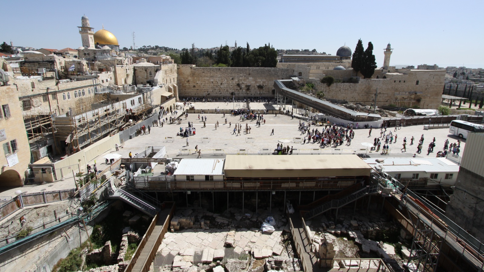
Excavations at the western end of Al-Buraq Square are continuing, and they raise fears that this Square will be expanded above and below the ground, to the detriment of the rest of the Old City. These excavations revealed results that were expected in advance, namely the Roman road from Bab al-Amud in the direction of the wad road (Cardo decamanus), clearly marked in the map of Madaba dating back to the end of the sixth century AD. A long section of this road has been uncovered, and Byzantine, Umayyad, crusader, Ayyubid and Mamluk buildings have been discovered on top of it, as well as part of the destroyed buildings of the Moorish lane. The reason for carrying out these excavations is due to a request by the Wailing Wall administration for the construction of a multi-purpose hall and additional service centers. We do not know what the fate of the important finds at this site will be, but it is assumed that, since the Old City is on the World Heritage list of historical sites, all forms of construction in it will be prohibited, and this is applied to the Palestinian population.
Excavations of the western tunnel:
It is the tunnel that is located along the Western Wall of the Haram al-Sharif. The excavations here are continuing non-stop, and they are mostly heading in the direction of the West, but in fact we do not know much about their tracks, as only those that are heading west, away from the Haram al-Sharif, are announced, as for the excavations that are heading east, in the direction of the Haram, we do not pretend that we know anything about them, and the most dangerous thing about them is that we do not know. Its tracks can sometimes be inferred by following the sounds emanating from the underground, but without being sure of the overall picture. The multiple data received by interested residents of the buildings located above the tunnels indicate the direction of these tunnels in various directions under the Old City, and we cannot give more information about them, because we lack clear facts, but we can point out that the bottom of the Ohel Yitzhak synagogue (listed below) was connected to a tunnel leading from West to east to meet the tunnel of the Western Wall
Excavations of the Ohel Yitzhak synagogue:
This synagogue is about fifty meters west of Al-Aqsa Mosque, and is located to the south of Hammam Al-Ain, located on wad road. Last year, this synagogue was built with two layers above a property that was confiscated in the seventies of the last century, and the construction of the synagogue was completed and inaugurated in a year .2008 as for the bottom of the synagogue called "Ohel Yitzhak", the excavation work began below the building level, and has now reached a level of more than ten meters, and is yet to be completed, while the excavation was carried out in the area behind the said synagogue (Hosh al-Zarba) to depths of more than 12 meters, so that this area was connected to the western tunnel that runs along the Western Wall of the Haram al-Sharif. The declared intentions regarding these excavations say that they may reach about 20 meters, and their goal is to create a museum of Jerusalem's archaeological layers. These excavations have led to the cracking of many buildings in the area, and the collapse of the road leading to Hosh al-Zarba, knowing that the buildings are densely populated. It is noteworthy that the results of excavations that reached the rock layer resulted in the discovery of archaeological layers starting from the Roman period and ending with the Ottoman period, and a huge hall (27.8 m × 10.3 M) was discovered, most likely, part of the Khan Tanq (Mamluk), which is located to the north of this site. Thus, the results of the excavations came as an additional boost to the archaeological excavation project here, as the settlers acquired an additional site, a spacious hall with multiple capabilities and uses, and all this was connected to the western tunnel extending on the Western Wall of the Haram al-Sharif, i.e. the site was connected to Al-Buraq square, so that it forms an integrated unit. The settlers claim ownership not only of the building, but also of everything that can be discovered underground. Although the above-ground buildings are private property and an Islamic Waqf, the settlers, with the support of the Israel Antiquities Authority and, of course, the Jerusalem Municipality, Act as the exclusive owner. It is worth noting that excavations in this area have led to the cracking of many houses located above the tunnels being dug, which are densely populated houses, however, the excavations have not yet ended, and we do not know exactly which direction they will go, and what additional settlement projects they may produce in this sensitive area, which is at the heart of the conflict .
Excavations of the hutsalam house (Sharon House):
This outpost is located in the northern area of the Valley Road, to the north of the Austrian Inn. We do not know anything about the circular excavations in it, but it is believed that they are carried out in two directions, the first to the north in the direction of the grotto (Solomon's grotto/ linen grotto) located near the door of the column, outside the walls, in order to connect the two sites one with the other, and the second direction is towards the south, where the site will be linked to the said Ohel Yitzhak synagogue, and therefore to the western tunnel and the Buraq square. This project demonstrates the tireless work to connect the outposts from underground,and to control more spaces within the Old City .
Fossil of the land of patience:
This land/ruin is located in the southern part of the AL-khawajat market, which was destroyed, most likely, in the nineteenth century as a result of an earthquake, and has not been rebuilt. The settlers have taken over the land and are now excavating it in preparation for building on it to expand the existing colonies in Aqaba al-Saraya. Using the surfaces of the articles of the Journal of Palestinian Studies Vol., 20 No. 79 (summer 2009), p.39 5 shops (perfumers ' market, welders and Khawajas) this colony is connected by Jewish sailors. The excavations are being carried out by the Israel Antiquities Authority in preparation for delivery to the settlers from Ateret Kohanim .
Excavations of the stork Tower:
This area is a vast land located in the north-eastern corner of the Old Town, and based on part of this land is the Burj Al-luqluq Community Association, which provides cultural, sports and health services to one of the poorest neighborhoods of the Old Town. And not far from this land there is an outpost. This land has been under settlement pressure for years, which is being met with resistance from the Palestinian residents of the neighborhood. The settlement associations have applied for a building permit for 36 housing units in addition to a synagogue with a golden dome, so the Israel Antiquities Authority came to the site to dig it before allowing the settlers to build. The Antiquities Authority did not object to the principle of building on the site located directly under the historical wall, and in a very vital area that forms an outlet for the very densely populated neighborhood, but excavated it, because the results of excavations indicated intensive use of the site in the Roman and Mamluk periods, and therefore, the site cannot be linked to anything related to Jewish history, which led to the approval of this authority to allow construction on the site. The project has not yet been implemented due to various problems related to the ownership of the land and the protest of some Israeli archaeologists against the idea, and the topic has been shelved for a certain period, and I am not surprised that it will be reopened again in the coming period, and during the period of the current government that supports the settlement greatly. Once again it becomes clear from this example that the settlement, the authority of archeologiesand the municipality all meet on the same agenda .
Tunnels of the lane of Honor / Jews:
Plans have been announced to build more tunnels connecting this area to Al-Buraq Square, but we do not know the details of these works yet.
Excavations outside the walls near the Old Town (the so-called Holy Basin)
The excavation of the so-called gafaati parking lot:
This land is located fifty meters from the southern wall of Jerusalem, near the Haram al-Sharif, and has an area of almost 10 dunums. Excavations have been taking place at the site for more than two years, and have so far revealed Muslim graves (more than 100 bodies)(16) and huge Umayyad buildings, (17) it is believed that this area was part of the Administrative Complex (emirate House) Umayyad, which was built at the end of the VII century and the beginning of the VIII century AD. An Abbasid Lane was also discovered at the site, which gives the site a high degree of scientific importance, (18) as the Abbasid period is not well represented in the city. The dimensions of these excavations have not yet been revealed, but through the information revealed, a huge hall for settlers, a shopping center and parking lots will be built on the site.it is also possible to link the site through a tunnel to Al-Buraq Square from the north, while it can be linked to Ain Silwan from the South. The Settlement Association "Elad" has been funding excavations since 2007 and these excavations cost millions of dollars due to their access to great depths. It is noteworthy that the "city of David" Information Center, which is managed by the settlement movement itself, is located opposite the excavation, which confirms the connection of this excavation with the settlement project in Silwan .
Excavations of the land of Siam:
This land is located approximately 150 meters south of the southern wall of Jerusalem in Wadi Hilweh, in an area where the settlement movement is active, and in which a Roman tunnel was dug in the north direction through which excess rainwater was used to drain from the Old City in the south direction (Wadi Hilweh, and then to the valley of fire).
A few tens of meters have been excavated in a northerly direction so far, but the excavations are not over yet. It is worth noting that the excavations were carried out without the permission of the Antiquities Authority, and when some Israeli journalists raised this issue, the Antiquities Authority issued the necessary permits, without stopping the excavation, nor submitting the "Return" movement to the court, as is customary with the Palestinians.
As for the path of the excavation, it is located under the Houses of the inhabitants of the area, as well as under the public street. "Elad" considered itself the owner of the underground, and it behaves like a government, nothing is done in secret, because the government, the municipality and the authority of antiquities are the arms of the same entity. The residents of the area lost the case they filed against this excavation, which is taking place under their homes, without their permission, which also confirms the interconnectedness of the judicial system in Israel with this project.
Excavations of Ain Silwan:
Drilling at ain Silwan is taking place in three locations: north of Al Ain, south of Al Ain, and at the Silwan pond. Work is continuing with funding from settlement associations with the aim of connecting ein Silwan with a tunnel extending north in the direction of the Journal of Palestinian studies articles Vol., 20 No. 79 (summer 2009), pp. 39-6 the former excavation (land of Siam), and in the direction of Al-Haram al-Sharif. Archaeological activities in this area can be understood as part of a settlement plan on the one hand, and within the project of establishing a Jewish archaeological city on the other hand, through which the history of Jerusalem will be reconstructed based on the settlement narrative, which is considered more extreme and one-sided compared to even the official version. Excavations in this area have led to collapses on the highway and cracks in some houses, and there is not enough information about the fossil here in order to reach scientific results regarding the finds.
Excavations of the hill of dahur (city of David):
Excavations are still ongoing at this site, and this is nothing new, but rehabilitation work is being carried out by settlers who have erected on the edge of the site a propaganda building that selectively and controversially synthesizes the history of Jerusalem even among Israeli archaeologists. The site includes an audio-visual presentation of the history of the hill and its relationship with the Jews, and the settlers are guided by tour guides at the site who present the picture in a clear approach. The latest excavations are centered around Al Ain (ain Umm Al-Derg), where defensive towers dating back to the Middle Bronze Age (Canaanite period) have been uncovered.
Tunnel warfare
The phenomenon of tunnels is not new in a city like Jerusalem, which contains many archaeological layers, and buildings piled on top of each other, and the topography of the city played an important role in the formation of tunnels.
There are several types of tunnels :
1. One of them came as a result of the construction of a bridge between two high areas between which there is a valley, and dust has accumulated over the ages and was forgotten about until it was discovered in one of the excavations that took place since the second half of the nineteenth century .
2. The second type of tunnels came as a result of sanitary extensions to remove rainwater or waste water, or even to draw and distribute fresh water, as the city has been connected over the ages with networks of these extensions that have been forgotten after modern extensions, and have been rediscovered old or modern .
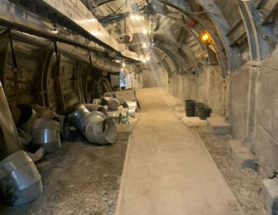
3. There are tunnels that came as a result of upgrading buildings, especially in the area around the Haram al-Sharif, and the tunnel that opened along the Western Wall of the Haram al-Sharif can be considered as one of these group .
4. There are tunnels that are being dug anewand did not have a historical origin, such as the scheme of connecting the Jewish lane to the Buraq square, or the scheme of connecting Solomon's grotto to Sharon's House
The most famous tunnels dug in Jerusalem are
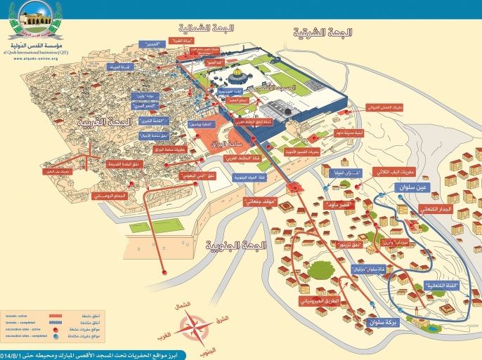
The western tunnel:
The tunnel is located along the Western Wall of Al-Haram al-Sharif, and it starts at the bottom of the AL-tanziz school adjacent to what is exposed from the Western Wall of the campus from the south side, and continues to the northwestern corner of the campus at Bab al-ghawanmeh, and bypasses it in the north direction. The length of the tunnel (from the northern corner of the Wailing Wall) is 330 meters along the Western Wall, after which it extends about 35 meters to the north of the Haram al-Sharif, and then deviates to the East about 16 meters, to open on the path of pain under the al-Omari school. The tunnel was named the Hasmonean tunnel by Israel, (21) due to the presence of a water channel in the northern part of the tunnel with a length of about 35 meters, starting below the school of the Sisters of Zion, where a water collection pond is believed to have been built during the said period.
The remaining parts of the tunnel are the foundations of the Mamluk buildings built on top of them, in addition to parts dating back to the Crusader or Ayyubid period, especially at the southern beginning of the tunnel.
Only two tiles dating back to the period of King Herod have been discovered, and we do not know if they were part of a tiled road, or if they were reused at the site during later periods . It is worth noting, that parts of the tunnel have been known since the XIX century. This tunnel forms the foundations of the Mamluk buildings located along the Western Wall of the Haram, as the Mamluks decided to raise the level of the buildings connected to the Haram from the western side to the level of the courtyards of the Haram.
Since the western area of the campus slopes down to the west to form a deep valley (the area is still called wad road), the buildings had to be raised on supports and settlements that formed a series of underground rooms and corridors, some of which were filled with dirt and architectural remains over the ages, and others were used as wells to collect rainwater for the buildings located above. A year later, in 1967, excavation works began (especially in the northern area of the tunnel, where the Rock was dug to form a northern exit to the tunnel) and cleaning, to be opened by Benjamin Netanyahu in the articles of the Journal of Palestinian Studies Vol., 20 No. 79 (summer 2009), pp. 39-7, 1996/9/23, thus launching what was called the tunnel intifada. It is also useful to know that parts of the tunnel are no more than 60 cm wide, which means that the visitor must walk in One Direction (currently from south to North), therefore, if the northern exit (under the age school) is closed, it means that the tunnel will be paralyzed from a tourist point of view . It should also be recalled that the tunnel branches underground into several secondary tunnels, not all of which we know because they are not open to visitors, and some of them are heading towards the Haram al-Sharif (that is, in the direction of the East), therefore, talking about the "tunnel" is not enough, as we have to take those branches into account.(22) the beginning of excavations in the tunnel in the early seventies led to cracks and collapses in a large number of Mamluk buildings located above, knowing that the beginning of excavations was carried out by settlers, and the management of the Western Wall is without archaeological or engineering supervision. And this issue is not over yet at many sites in the Old Town
Ein Silwan tunnel:
This tunnel is located under the part called the "city of David" in Silwan, and it was discovered by archaeologist Eilat Mazar, a very fanatical Zionist, and her writings lack, even among Israeli archaeologists, scientific credibility, and it was she who stirred up confusion about the excavations of the Maronite Chapel, and created an association to defend the "Temple Mount". This scientist announced the discovery of the tunnel in 2008 and dated it back to the tenth century BC, that is, to the period of King David, although no one can say for sure the accuracy of the date, even the researcher herself made her discovery cautiously. So far, about 50 meters have been uncovered, and work is underway in the tunnel from Ein Silwan in the direction of the Old City, (23) the tunnel will be used to connect the "city of David" with Silwan water projects and the Buraq Wall, and will contribute to expanding the influence of settlers, and will also lead to the crystallization of an integrated Zionist narrative about the history of Jerusalem
Sweet Valley tunnel:
The tunnel is located along the Wadi Hilweh road, it connects Silwan and the Old Town, and it is called the "beginning of David", and the colonies have spread along this road, after controlling about 15 buildings. The settlement project here aims to empty the entire Hilweh Valley of residents, and to connect ain Silwan with a road leading from the door of the Moroccans in the Jerusalem wall at the southern wall of the Al-Aqsa Mosque to Ain Silwan and the Bustan area, and this road is a center of intensive traffic for cars and pedestrians. Drilling in the tunnel began in 2004 under a secretly guarded tent, and we do not know to what extent the drilling was carried out, but the passage of five years after the drilling, and the sight of a large amount of trucks transporting the extracted dirt from the tunnel, indicate the extent that has been traveled. Most likely, this tunnel was a stream of fresh water from the Old City in the direction of the Sweet Valley, and then to the valley of fire . The most dangerous thing about the tunnels is that we do not know the plans, because the work in them remains under secrecy, as well as not allowing property owners, their lawyers, or even journalists to approach them, not for the sake of public safety, as is the case with dangerous excavations, but to preserve the secrecy of the project. The tunnels in the Old City and its surroundings have been associated with settlement movements, which indicates their connection with settlement projects
The above-mentioned information shows the extent of the settlement offensive, which is concentrated in the Old City and the surrounding area, in an attempt to resolve the situation on the ground unilaterally. The campaign takes the following manifestations
* The use of archaeological excavationsas an excuse for intervention and control, after archeology comes settlement .
* Intensification of settlement operations in Ras al-Amud, Silwan, Hilweh Valley, Sheikh Jarrah and, of course, the Old Town .
* Expulsion of Palestinians from Silwan, Al-Bustan neighborhood, and Sheikh Jarrah .
* Demolition of houses in the settlement-targeted areas.
Objectives
In general, the purpose of excavations and tunnels is to search for Jewish archaeological remains that may constitute evidence or witness to the existence of the history of the Jews in Jerusalem, but in particular it is to search for remains and evidence of the existence of the first or Second Temple, to weave the narrative of the restoration of the construction of the alleged Third Temple.
The occupation authorities also aim to create an imaginary Hebrew history by claiming to link the archaeological assets of the Hebrew period to Jerusalem.
The other goal is to obliterate and destroy the ancient Islamic and Arab Monuments that constitute the real evidence of the ancient Arab and Islamic civilization in Jerusalem.
The Israeli authorities are also working to bring the remaining Jews to the promised land, linking foreign tourists to this land, especially Christians, in addition to building a historical Jewish city, instead of not finding remains and evidence of the alleged temple.
Risks and consequences
The excavations led to the systematic destruction of many monuments above and below the ground, the demolition of archaeological layers of all periods (Arab, then Islamic, from Umayyad to Ottoman).
It also led to the creation of cracks and demolition in the walls, floors and buildings of the Al-Aqsa Mosque, the buildings of Old Jerusalem, and Silwan, in an attempt to Judaize the surroundings of Al-Aqsa and the absence of cultural landmarks, especially the Supreme and giant.
These excavations also result in establishing control over the land, above and below, and turning it into Jewish settlement facilities serving the Zionist project, as many tunnels now contain synagogues and Biblical Talmudic shrines.